85
R E A L T Y M A R K E T I N G / N O R T H W E S T
100
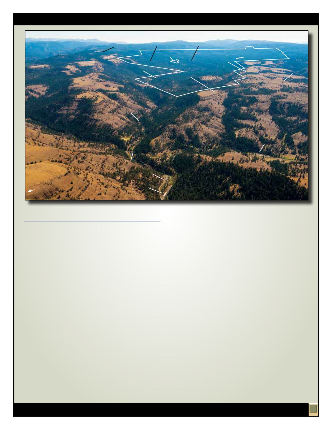
DESOLATION CREEK
13,440± ACRES
GRANT COUNTY, OREGON
Desolation Creek is the largest private block of ownership
within the Desolation Watershed which is tributary to
North Fork John Day River, 1.5± miles from the property.
Over ten miles of Desolation Creek runs on the property,
and supports Chinook salmon, steelhead, bull trout,
brook trout, cutthroat trout and mountain whitefish.
The North Fork John Day River and its tributaries
account for about 70% of the salmon production within
the John Day Basin, according to the U.S. Forest Service.
Acquisition of the Desolation Creek Tract provides
significant opportunity for a new owner to obtain
conservation values in restoration of the 20± miles of
riparian areas along Desolation Creek. Additional
riparian restoration opportunity includes: Kelsay,
Moonshine, Spring, Starveout and East Meadow Creeks.
86% of the Desolation Creek Tract, or 11,601± acres, is
classified as forestland, and is mostly located on north-
and west-facing slopes, with good site productivity.
Elevations range from 3,000± to 5,000± feet with a well-
developed system of both USFS and private roads. The
bulk of the property may be harvested using ground-
based systems.
The 2013 cruise estimates a total of 35,700± MBF, a 57%
increase from the 2001 volume, prior to purchase by
Hood River County. 72% of the 2013 estimated volume
is Douglas-fir and ponderosa pine, with the balance
being western larch, grand fir and lodgepole pine. The
Seller has harvested only 221.9± MBF during its ten-year
ownership. It has been projected that within the next 25
years timber volume will increase by over 265% to 96±
million board feet.
The Desolation Creek Tract is also an excellent hunting
and recreation property. It has not been leased for hunting
by the Seller. The combination of ridge tops, meadows,
steep draws and plentiful water have attracted both elk
and deer. There are numerous opportunities to develop
a private hunting retreat along ridge tops overlooking
the Desolation Creek Drainage in the southwest section
of the property. Currently, the property is leased
through 2014 to three ranchers for grazing purposes, and
generates annual income of $20,232. These leases may be
terminated or re-negotiated by the new owner upon sale
of the property.
Historically, a number of creek front cabins were built
along the north bank of Desolation Creek. There are two
remaining private in-holdings with cabins still on the
property. An old hunters’ cabin in disrepair remains in
the southwest section. Additional cabins or campgrounds
could be developed by a new owner in order to take
advantage of easy accessibility and vehicle traffic on
USFS Road 10 to Olive Lake, a popular campground that
is south of the property.
Highway 395
Texas Bar Road
Dale
USFS Road 10
Case Ridge
Duff Meadows
Wassen Meadows
Desolation
Creek
Out-Parcel
Moonshine
Creek
East Fork
Meadow
Creek
North Fork John Day River
Bridge Creek State
Wildlife Area
Desolation Creek
Desolation Creek
North Fork John
Day Wilderness
Onion Flats
N


